|
| at: |
DeSoto National Forest - Chickasawhay District |
Data from USFS GIS
 show on map
 animate
Trail users:


Elevation Profile
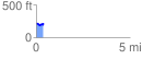
 0.381809 mi
 49.21 ft
 38.47 ft
 10.75 ft
 2.44 %
GPX Downloads: Track Route
![]()
|
| at: |
DeSoto National Forest - Chickasawhay District |
show on map
animate
0.381809 mi
49.21 ft
38.47 ft
10.75 ft
2.44 %