|
| at: |
DeSoto National Forest - Chickasawhay District |
Data from USFS GIS
 show on map
 animate
Trail users:


Elevation Profile
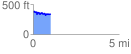
 1.004019 mi
 119.02 ft
 162.55 ft
 -43.52 ft
 3.07 %
GPX Downloads: Track Route
![]()
|
| at: |
DeSoto National Forest - Chickasawhay District |
show on map
animate
1.004019 mi
119.02 ft
162.55 ft
-43.52 ft
3.07 %