| at: |
DeSoto National Forest - Chickasawhay District |
Data from USFS GIS
 show on map
 animate
Trail users:


Elevation Profile
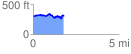
 1.789847 mi
 241.53 ft
 251.78 ft
 -10.26 ft
 2.66 %
GPX Downloads: Track Route
![]()
| at: |
DeSoto National Forest - Chickasawhay District |
show on map
animate
1.789847 mi
241.53 ft
251.78 ft
-10.26 ft
2.66 %