|
| at: |
DeSoto National Forest - Chickasawhay District |
Data from USFS GIS
 show on map
 animate
Trail users:


Elevation Profile
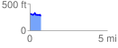
 0.703992 mi
 68.21 ft
 109.66 ft
 -41.45 ft
 2.95 %
GPX Downloads: Track Route
![]()
|
| at: |
DeSoto National Forest - Chickasawhay District |
show on map
animate
0.703992 mi
68.21 ft
109.66 ft
-41.45 ft
2.95 %