| at: |
DeSoto National Forest - Chickasawhay District |
Data from USFS GIS
 show on map
 animate
Trail users:


Elevation Profile
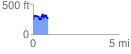
 0.891405 mi
 260.82 ft
 236.65 ft
 24.18 ft
 5.54 %
GPX Downloads: Track Route
![]()
| at: |
DeSoto National Forest - Chickasawhay District |
show on map
animate
0.891405 mi
260.82 ft
236.65 ft
24.18 ft
5.54 %