| at: |
DeSoto National Forest - Chickasawhay District |
Data from USFS GIS
 show on map
 animate
Trail users:


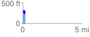
Elevation Profile
 0.210662 mi
 106.36 ft
 102.74 ft
 3.62 ft
 9.56 %
GPX Downloads: Track Route
![]()
| at: |
DeSoto National Forest - Chickasawhay District |
show on map
animate
0.210662 mi
106.36 ft
102.74 ft
3.62 ft
9.56 %