| at: |
DeSoto National Forest - Chickasawhay District |
Data from USFS GIS
 show on map
 animate
Trail users:


Elevation Profile
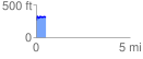
 0.503957 mi
 93.65 ft
 44.83 ft
 48.81 ft
 3.52 %
GPX Downloads: Track Route
![]()
| at: |
DeSoto National Forest - Chickasawhay District |
show on map
animate
0.503957 mi
93.65 ft
44.83 ft
48.81 ft
3.52 %