|
| at: |
DeSoto National Forest - Chickasawhay District |
Data from USFS GIS
 show on map
 animate
Trail users:


Elevation Profile
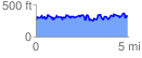
 4.987917 mi
 1123.86 ft
 1099.04 ft
 24.83 ft
 4.27 %
GPX Downloads: Track Route
![]()
|
| at: |
DeSoto National Forest - Chickasawhay District |
show on map
animate
4.987917 mi
1123.86 ft
1099.04 ft
24.83 ft
4.27 %