|
| at: |
DeSoto National Forest - Chickasawhay District |
Data from USFS GIS
 show on map
 animate
Trail users:


Elevation Profile
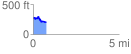
 0.764907 mi
 90.51 ft
 155.56 ft
 -65.05 ft
 3.85 %
GPX Downloads: Track Route
![]()
|
| at: |
DeSoto National Forest - Chickasawhay District |
show on map
animate
0.764907 mi
90.51 ft
155.56 ft
-65.05 ft
3.85 %