|
| at: |
DeSoto National Forest - Chickasawhay District |
Data from USFS GIS
 show on map
 animate
Trail users:


Elevation Profile
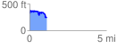
 1.106655 mi
 189.04 ft
 266.87 ft
 -77.83 ft
 4.57 %
GPX Downloads: Track Route
![]()
|
| at: |
DeSoto National Forest - Chickasawhay District |
show on map
animate
1.106655 mi
189.04 ft
266.87 ft
-77.83 ft
4.57 %