|
| at: |
DeSoto National Forest - Chickasawhay District |
Data from USFS GIS
 show on map
 animate
Trail users:


Elevation Profile
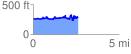
 2.624214 mi
 469.64 ft
 431.30 ft
 38.34 ft
 3.39 %
GPX Downloads: Track Route
![]()
|
| at: |
DeSoto National Forest - Chickasawhay District |
show on map
animate
2.624214 mi
469.64 ft
431.30 ft
38.34 ft
3.39 %