|
| at: |
DeSoto National Forest - Chickasawhay District |
Data from USFS GIS
 show on map
 animate
Trail users:


Elevation Profile
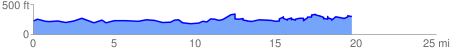
 20.644394 mi
 2097.55 ft
 2028.15 ft
 69.40 ft
 1.92 %
GPX Downloads: Track Route
![]()
|
| at: |
DeSoto National Forest - Chickasawhay District |
show on map
animate
20.644394 mi
2097.55 ft
2028.15 ft
69.40 ft
1.92 %