| at: |
DeSoto National Forest - Chickasawhay District |
Data from USFS GIS
 show on map
 animate
Trail users:


Elevation Profile
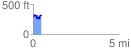
 0.464939 mi
 109.10 ft
 84.05 ft
 25.05 ft
 4.44 %
GPX Downloads: Track Route
![]()
| at: |
DeSoto National Forest - Chickasawhay District |
show on map
animate
0.464939 mi
109.10 ft
84.05 ft
25.05 ft
4.44 %