|
| at: |
DeSoto National Forest - Chickasawhay District |
Data from USFS GIS
 show on map
 animate
Trail users:


Elevation Profile
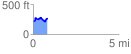
 0.834477 mi
 146.94 ft
 109.73 ft
 37.20 ft
 3.33 %
GPX Downloads: Track Route
![]()
|
| at: |
DeSoto National Forest - Chickasawhay District |
show on map
animate
0.834477 mi
146.94 ft
109.73 ft
37.20 ft
3.33 %