| at: |
DeSoto National Forest - Chickasawhay District |
Data from USFS GIS
 show on map
 animate
Trail users:


Elevation Profile
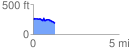
 1.275364 mi
 78.68 ft
 151.06 ft
 -72.38 ft
 2.24 %
GPX Downloads: Track Route
![]()
| at: |
DeSoto National Forest - Chickasawhay District |
show on map
animate
1.275364 mi
78.68 ft
151.06 ft
-72.38 ft
2.24 %