|
| at: |
DeSoto National Forest - Chickasawhay District |
Data from USFS GIS
 show on map
 animate
Trail users:


Elevation Profile
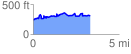
 3.396911 mi
 611.67 ft
 551.30 ft
 60.37 ft
 3.41 %
GPX Downloads: Track Route
![]()
|
| at: |
DeSoto National Forest - Chickasawhay District |
show on map
animate
3.396911 mi
611.67 ft
551.30 ft
60.37 ft
3.41 %