| at: |
DeSoto National Forest - Chickasawhay District |
Data from USFS GIS
 show on map
 animate
Trail users:


Elevation Profile
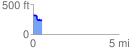
 0.539782 mi
 29.98 ft
 115.01 ft
 -85.03 ft
 4.04 %
GPX Downloads: Track Route
![]()
| at: |
DeSoto National Forest - Chickasawhay District |
show on map
animate
0.539782 mi
29.98 ft
115.01 ft
-85.03 ft
4.04 %