|
| at: |
DeSoto National Forest - Chickasawhay District |
Data from USFS GIS
 show on map
 animate
Trail users:


Elevation Profile
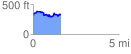
 1.613609 mi
 211.47 ft
 197.31 ft
 14.16 ft
 2.48 %
GPX Downloads: Track Route
![]()
|
| at: |
DeSoto National Forest - Chickasawhay District |
show on map
animate
1.613609 mi
211.47 ft
197.31 ft
14.16 ft
2.48 %