|
| at: |
DeSoto National Forest - Chickasawhay District |
Data from USFS GIS
 show on map
 animate
Trail users:


Elevation Profile
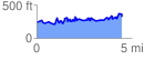
 4.473614 mi
 720.30 ft
 644.03 ft
 76.27 ft
 3.05 %
GPX Downloads: Track Route
![]()
|
| at: |
DeSoto National Forest - Chickasawhay District |
show on map
animate
4.473614 mi
720.30 ft
644.03 ft
76.27 ft
3.05 %