| at: |
DeSoto National Forest - Chickasawhay District |
Data from USFS GIS
 show on map
 animate
Trail users:


Elevation Profile
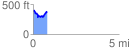
 0.806315 mi
 158.58 ft
 176.92 ft
 -18.35 ft
 4.16 %
GPX Downloads: Track Route
![]()
| at: |
DeSoto National Forest - Chickasawhay District |
show on map
animate
0.806315 mi
158.58 ft
176.92 ft
-18.35 ft
4.16 %