| at: |
DeSoto National Forest - Chickasawhay District |
Data from USFS GIS
 show on map
 animate
Trail users:


Elevation Profile
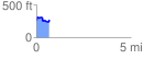
 0.693045 mi
 114.14 ft
 97.86 ft
 16.28 ft
 3.12 %
GPX Downloads: Track Route
![]()
| at: |
DeSoto National Forest - Chickasawhay District |
show on map
animate
0.693045 mi
114.14 ft
97.86 ft
16.28 ft
3.12 %