|
| at: |
DeSoto National Forest - Chickasawhay District |
Data from USFS GIS
 show on map
 animate
Trail users:


Elevation Profile
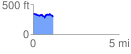
 1.200437 mi
 117.89 ft
 175.65 ft
 -57.76 ft
 2.77 %
GPX Downloads: Track Route
![]()
|
| at: |
DeSoto National Forest - Chickasawhay District |
show on map
animate
1.200437 mi
117.89 ft
175.65 ft
-57.76 ft
2.77 %