| at: |
DeSoto National Forest - Chickasawhay District |
Data from USFS GIS
 show on map
 animate
Trail users:


Elevation Profile
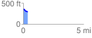
 0.361678 mi
 5.45 ft
 81.33 ft
 -75.88 ft
 4.26 %
GPX Downloads: Track Route
![]()
| at: |
DeSoto National Forest - Chickasawhay District |
show on map
animate
0.361678 mi
5.45 ft
81.33 ft
-75.88 ft
4.26 %