| at: |
DeSoto National Forest - Chickasawhay District |
Data from USFS GIS
 show on map
 animate
Trail users:


Elevation Profile
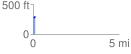
 0.127017 mi
 22.25 ft
 8.74 ft
 13.51 ft
 3.32 %
GPX Downloads: Track Route
![]()
| at: |
DeSoto National Forest - Chickasawhay District |
show on map
animate
0.127017 mi
22.25 ft
8.74 ft
13.51 ft
3.32 %