|
| at: |
DeSoto National Forest - Chickasawhay District |
Data from USFS GIS
 show on map
 animate
Trail users:


Elevation Profile
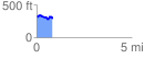
 0.848999 mi
 131.72 ft
 168.08 ft
 -36.36 ft
 3.75 %
GPX Downloads: Track Route
![]()
|
| at: |
DeSoto National Forest - Chickasawhay District |
show on map
animate
0.848999 mi
131.72 ft
168.08 ft
-36.36 ft
3.75 %