|
| at: |
DeSoto National Forest - Chickasawhay District |
Data from USFS GIS
 show on map
 animate
Trail users:


Elevation Profile
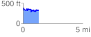
 1.304382 mi
 277.63 ft
 273.52 ft
 4.11 ft
 4.03 %
GPX Downloads: Track Route
![]()
|
| at: |
DeSoto National Forest - Chickasawhay District |
show on map
animate
1.304382 mi
277.63 ft
273.52 ft
4.11 ft
4.03 %