| at: |
DeSoto National Forest - Chickasawhay District |
Data from USFS GIS
 show on map
 animate
Trail users:


Elevation Profile
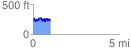
 1.024191 mi
 219.74 ft
 223.25 ft
 -3.51 ft
 4.13 %
GPX Downloads: Track Route
![]()
| at: |
DeSoto National Forest - Chickasawhay District |
show on map
animate
1.024191 mi
219.74 ft
223.25 ft
-3.51 ft
4.13 %