|
| at: |
DeSoto National Forest - Chickasawhay District |
Data from USFS GIS
 show on map
 animate
Trail users:


Elevation Profile
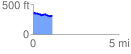
 1.127478 mi
 127.27 ft
 156.99 ft
 -29.72 ft
 2.64 %
GPX Downloads: Track Route
![]()
|
| at: |
DeSoto National Forest - Chickasawhay District |
show on map
animate
1.127478 mi
127.27 ft
156.99 ft
-29.72 ft
2.64 %