| at: |
DeSoto National Forest - Chickasawhay District |
Data from USFS GIS
 show on map
 animate
Trail users:


Elevation Profile
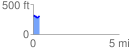
 0.396155 mi
 51.59 ft
 39.03 ft
 12.56 ft
 2.47 %
GPX Downloads: Track Route
![]()
| at: |
DeSoto National Forest - Chickasawhay District |
show on map
animate
0.396155 mi
51.59 ft
39.03 ft
12.56 ft
2.47 %