|
| at: |
DeSoto National Forest - Chickasawhay District |
Data from USFS GIS
 show on map
 animate
Trail users:


Elevation Profile
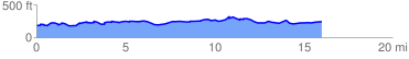
 16.379397 mi
 1221.10 ft
 1171.14 ft
 49.97 ft
 1.41 %
GPX Downloads: Track Route
![]()
|
| at: |
DeSoto National Forest - Chickasawhay District |
show on map
animate
16.379397 mi
1221.10 ft
1171.14 ft
49.97 ft
1.41 %