|
| at: |
DeSoto National Forest - Chickasawhay District |
Data from USFS GIS
 show on map
 animate
Trail users:


Elevation Profile
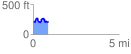
 0.865205 mi
 157.32 ft
 160.35 ft
 -3.03 ft
 3.51 %
GPX Downloads: Track Route
![]()
|
| at: |
DeSoto National Forest - Chickasawhay District |
show on map
animate
0.865205 mi
157.32 ft
160.35 ft
-3.03 ft
3.51 %