|
| at: |
DeSoto National Forest - Chickasawhay District |
Data from USFS GIS
 show on map
 animate
Trail users:


Elevation Profile
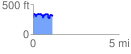
 1.155951 mi
 306.73 ft
 283.87 ft
 22.86 ft
 5.03 %
GPX Downloads: Track Route
![]()
|
| at: |
DeSoto National Forest - Chickasawhay District |
show on map
animate
1.155951 mi
306.73 ft
283.87 ft
22.86 ft
5.03 %