| at: |
DeSoto National Forest - Chickasawhay District |
Data from USFS GIS
 show on map
 animate
Trail users:


Elevation Profile
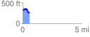
 0.572534 mi
 123.07 ft
 172.70 ft
 -49.64 ft
 5.71 %
GPX Downloads: Track Route
![]()
| at: |
DeSoto National Forest - Chickasawhay District |
show on map
animate
0.572534 mi
123.07 ft
172.70 ft
-49.64 ft
5.71 %