| at: |
DeSoto National Forest - Chickasawhay District |
Data from USFS GIS
 show on map
 animate
Trail users:


Elevation Profile
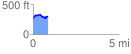
 0.851262 mi
 104.16 ft
 85.53 ft
 18.63 ft
 2.32 %
GPX Downloads: Track Route
![]()
| at: |
DeSoto National Forest - Chickasawhay District |
show on map
animate
0.851262 mi
104.16 ft
85.53 ft
18.63 ft
2.32 %