| at: |
DeSoto National Forest - Chickasawhay District |
Data from USFS GIS
 show on map
 animate
Trail users:


Elevation Profile
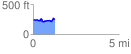
 1.267086 mi
 130.73 ft
 112.49 ft
 18.24 ft
 1.95 %
GPX Downloads: Track Route
![]()
| at: |
DeSoto National Forest - Chickasawhay District |
show on map
animate
1.267086 mi
130.73 ft
112.49 ft
18.24 ft
1.95 %