|
| at: |
DeSoto National Forest - Chickasawhay District |
Data from USFS GIS
 show on map
 animate
Trail users:


Elevation Profile
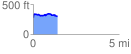
 1.403381 mi
 138.00 ft
 131.54 ft
 6.46 ft
 1.86 %
GPX Downloads: Track Route
![]()
|
| at: |
DeSoto National Forest - Chickasawhay District |
show on map
animate
1.403381 mi
138.00 ft
131.54 ft
6.46 ft
1.86 %