|
| at: |
DeSoto National Forest - Chickasawhay District |
Data from USFS GIS
 show on map
 animate
Trail users:


Elevation Profile
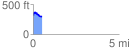
 0.514672 mi
 72.99 ft
 87.87 ft
 -14.88 ft
 3.23 %
GPX Downloads: Track Route
![]()
|
| at: |
DeSoto National Forest - Chickasawhay District |
show on map
animate
0.514672 mi
72.99 ft
87.87 ft
-14.88 ft
3.23 %