|
| at: |
DeSoto National Forest - Chickasawhay District |
Data from USFS GIS
 show on map
 animate
Trail users:


Elevation Profile
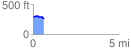
 0.624592 mi
 40.50 ft
 69.45 ft
 -28.95 ft
 2.11 %
GPX Downloads: Track Route
![]()
|
| at: |
DeSoto National Forest - Chickasawhay District |
show on map
animate
0.624592 mi
40.50 ft
69.45 ft
-28.95 ft
2.11 %