| at: |
DeSoto National Forest - Chickasawhay District |
Data from USFS GIS
 show on map
 animate
Trail users:


Elevation Profile
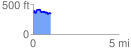
 1.048167 mi
 144.03 ft
 151.12 ft
 -7.09 ft
 2.73 %
GPX Downloads: Track Route
![]()
| at: |
DeSoto National Forest - Chickasawhay District |
show on map
animate
1.048167 mi
144.03 ft
151.12 ft
-7.09 ft
2.73 %