| at: |
DeSoto National Forest - Chickasawhay District |
Data from USFS GIS
 show on map
 animate
Trail users:


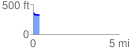
Elevation Profile
 0.362800 mi
 12.29 ft
 64.69 ft
 -52.40 ft
 3.38 %
GPX Downloads: Track Route
![]()
| at: |
DeSoto National Forest - Chickasawhay District |
show on map
animate
0.362800 mi
12.29 ft
64.69 ft
-52.40 ft
3.38 %