|
| at: |
DeSoto National Forest - Chickasawhay District |
Data from USFS GIS
 show on map
 animate
Trail users:


Elevation Profile
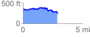
 2.925779 mi
 375.01 ft
 490.65 ft
 -115.64 ft
 3.18 %
GPX Downloads: Track Route
![]()
|
| at: |
DeSoto National Forest - Chickasawhay District |
show on map
animate
2.925779 mi
375.01 ft
490.65 ft
-115.64 ft
3.18 %