| at: |
DeSoto National Forest - Chickasawhay District |
Data from USFS GIS
 show on map
 animate
Trail users:


Elevation Profile
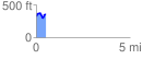
 0.500818 mi
 111.08 ft
 81.14 ft
 29.94 ft
 4.20 %
GPX Downloads: Track Route
![]()
| at: |
DeSoto National Forest - Chickasawhay District |
show on map
animate
0.500818 mi
111.08 ft
81.14 ft
29.94 ft
4.20 %