| at: |
DeSoto National Forest - Chickasawhay District |
Data from USFS GIS
 show on map
 animate
Trail users:


Elevation Profile
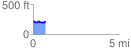
 0.713283 mi
 58.79 ft
 54.29 ft
 4.50 ft
 1.56 %
GPX Downloads: Track Route
![]()
| at: |
DeSoto National Forest - Chickasawhay District |
show on map
animate
0.713283 mi
58.79 ft
54.29 ft
4.50 ft
1.56 %