| at: |
DeSoto National Forest - Chickasawhay District |
Data from USFS GIS
 show on map
 animate
Trail users:


Elevation Profile
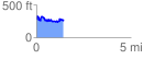
 1.448051 mi
 271.61 ft
 292.91 ft
 -21.30 ft
 3.83 %
GPX Downloads: Track Route
![]()
| at: |
DeSoto National Forest - Chickasawhay District |
show on map
animate
1.448051 mi
271.61 ft
292.91 ft
-21.30 ft
3.83 %