| at: |
DeSoto National Forest - Chickasawhay District |
Data from USFS GIS
 show on map
 animate
Trail users:


Elevation Profile
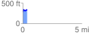
 0.360939 mi
 91.19 ft
 45.24 ft
 45.95 ft
 4.78 %
GPX Downloads: Track Route
![]()
| at: |
DeSoto National Forest - Chickasawhay District |
show on map
animate
0.360939 mi
91.19 ft
45.24 ft
45.95 ft
4.78 %