| at: |
DeSoto National Forest - Chickasawhay District |
Data from USFS GIS
 show on map
 animate
Trail users:


Elevation Profile
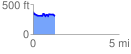
 1.256252 mi
 142.32 ft
 196.71 ft
 -54.39 ft
 2.97 %
GPX Downloads: Track Route
![]()
| at: |
DeSoto National Forest - Chickasawhay District |
show on map
animate
1.256252 mi
142.32 ft
196.71 ft
-54.39 ft
2.97 %