|
| at: |
DeSoto National Forest - Chickasawhay District |
Data from USFS GIS
 show on map
 animate
Trail users:


Elevation Profile
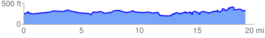
 19.374443 mi
 2236.66 ft
 2141.66 ft
 95.00 ft
 2.19 %
GPX Downloads: Track Route
![]()
|
| at: |
DeSoto National Forest - Chickasawhay District |
show on map
animate
19.374443 mi
2236.66 ft
2141.66 ft
95.00 ft
2.19 %