| at: |
DeSoto National Forest - Chickasawhay District |
Data from USFS GIS
 show on map
 animate
Trail users:


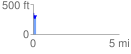
Elevation Profile
 0.195671 mi
 65.34 ft
 74.94 ft
 -9.61 ft
 7.25 %
GPX Downloads: Track Route
![]()
| at: |
DeSoto National Forest - Chickasawhay District |
show on map
animate
0.195671 mi
65.34 ft
74.94 ft
-9.61 ft
7.25 %