| at: |
DeSoto National Forest - Chickasawhay District |
Data from USFS GIS
 show on map
 animate
Trail users:


Elevation Profile
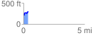
 0.396048 mi
 123.66 ft
 27.82 ft
 95.84 ft
 5.91 %
GPX Downloads: Track Route
![]()
| at: |
DeSoto National Forest - Chickasawhay District |
show on map
animate
0.396048 mi
123.66 ft
27.82 ft
95.84 ft
5.91 %