|
| at: |
DeSoto National Forest - Chickasawhay District |
Data from USFS GIS
 show on map
 animate
Trail users:


Elevation Profile
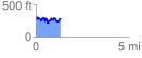
 1.335118 mi
 313.48 ft
 283.35 ft
 30.13 ft
 4.45 %
GPX Downloads: Track Route
![]()
|
| at: |
DeSoto National Forest - Chickasawhay District |
show on map
animate
1.335118 mi
313.48 ft
283.35 ft
30.13 ft
4.45 %